
Bovec and surrounding of the Soca river
 Routes
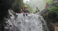
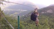
Places of interest
River sections
Acomodations
Base address: Čezsoča 13, 5230 Bovec (2 minutes from Bovec , on the riverside of Soca)
GPS: 46 19'22 .68 N, 13 33'08 .00 E
Cezsoca- drawn map of the base location
Office address: Trg golobarskih žrtev 38 5230 Bovec (the opposite side of the Tourist Office , on the main square of Bovec)
The Soca Valley with all the interesting places, apartments, river sections, and routes from Budapest. You can zoom in and move around on the map with the navigation buttons that you find on the upper left corner.
Routes: Bp-Bovec
| Budapest - Bovec 4 route variations | Google Earth | Google Map | Picture |
| The fastes way: Bp (M7-M70-A5) - Maribor (A1) - Graz (A2,) -Tarvisio (SS54) - Bovec (You need 3 highway vignette!) | Google Earth | Google Map | Pictures |
| Bp (M7-M70-A5) - Maribor (A1, E57) - Ljubjana (A2, E61) - Kranj (A2) - Bled (A2, E61) - Jesenice (201) Here,you have to leave the highway) - Tarvisio (SS54) - Bovec 580 km | Google Earth | Google Map | Pictures |
| Bp (M7) - Székesfehérvár (8) - Rábafüzes (E66)- Graz (A2) - Klagenfurt (A2) - Villah (A2) - Tarvisio (SS54) - Bovec 560 km | Google Earth | Google Map | Pictures |
| Bp (M1-A4) - Pandorf (50) - Eisenstadt (S31-S4-A2) or Schwechat (A4-S1-A2) - Graz (A2) - Klagenfurt- Villah- Tarvisio (SS54) - Bovec 610 km or 640 km | Google Earth | Google Map | Pictures |
Vignette prices:
- Hungary: 2.975 Ft (for a week), 4780 (1 month)
- Austria: 8,5 EUR (for 10 days), 24,8 EUR (2 month)
- Slovenia: 15 EUR (for a week), 30 EUR (1 month)
Bovec area with Googel Earth:
| From Tarvisio to our base | Google Earth | Google Map | Picture |
| Bovec area from Tarvisio | Google Earth | Google Map | Picture |
| Cezsoca and our base with apartments | Google Earth | Google Map | Picture |
| Bovec area with apartments | Google Earth | Google Map | Picture |
|
Entire Soca Valley with POI! |
Google Earth | Google Map | Picture |
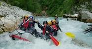
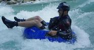
You are able to paddle on these sections of the Soca River:
| Section | Description | Google Earth | Google Map | Picture |
| Bunkerji - Cezsoca | WW II-IV. We usually paddle the upper section on Sunday. The end of this section is in Cezsoca ( our base ) | Google Earth | Google Map | Picture |
| Cezsoca -Srpenica | WW I-III We paddle on this section when Soca is flooded or we teach beginner kayakers. It is from our base to Spernica. | Google Earth | Google Map | Picture |
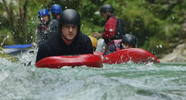
| Boka-Tronovo | WW II-IV It is the most common section. We are able to paddle, both with canoe or rafting boat, swim with hydro speed, or take advance kayak class during the season | Google Earth | Google Map | Picture |
| Otona-Kobarid | WW III-IV It is the hardest, but still safe section. We offer this section only advanced tourist in small groups and mainly on weekdays. | Google Earth | Google Map | Picture |
| Bunkerij-Kobarid | All white water section on the Soca River. | Google Earth | Google Map | Picture |
We founded our Slovenian company and named Froccs Doo in 2003. We have all necessary licenses to organize and guide a rafting trip.